Hiking in the Prino Valley
From our Agritourism there are several very interesting hiking trails. All the villages of the valleys are connected by a network of paths and ancient mule tracks that before the second post-war period were the only means of communication for the inhabitants of the valley with the coast and the Lower Piedmont Passes. On the farm we will provide specific directions for pleasant walks. For German-speaking customers we recommend the website of the Biologist Dr. Gert Heller www.gertheller.it

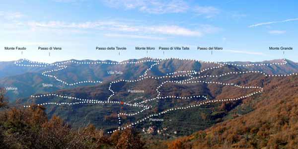
Visit to the Fenaira mountain pasture and the menhir of San Lorenzo

We start from the farm and continue towards Colle d’Oggia by car for 8 km. At the Colle dʻOggia continue for S. Bernardo di Conio, and then Passo Teglia.
300 meters before the pass, on the left is the Schenardi farm pasture where it is possible to taste and buy fantastic goat cheeses, goat ricotta and the unmissable “bruzzo”.
The mountain pasture is open from the beginning of June to the beginning of September.
Arriving at Passo della Teglia take the road in the woods towards Sotto di S. Lorenzo: enter the dense beech forest along a beautiful mule track, almost flat, up to the magical valley of Sotto di San Lorenzo, a doline where in ancient times religious rites were celebrated; a coppella and a menhir are still its witnesses.
Then continue to the Passo della Mezzaluna, perhaps a legacy of ancient Saracen settlements; from here you climb steeply along the grassy slope of Mount Monega until you reach the top from where the view stretches from the sea to the mountains. The return will take place for a stretch on the mule track that goes from the Pian del Latte Pass to the Passo della Mezzaluna and to the starting base.
Difficulty: E – Difference in altitude: 600 meters – Distance: 12 km – Travel time: 5 hours.
Recommended link: <a href=”http://parconaturalealpiliguri.it/”>Parco Naturale Alpi Liguri</a>
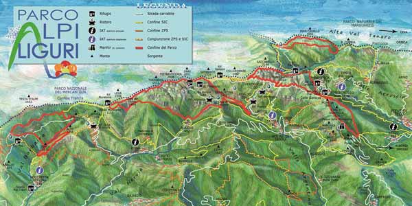
The Natural Park of the Ligurian Alps and the Alta Via dei Monti Liguri

The network of itineraries in the Natural Park of the Ligurian Alps is also a support base for the most varied offer of walks and excursions in the hinterland. Through paths and dirt roads it is possible to move from one valley to another using ancient ridge routes that are now restored, offering magnificent 360 ° views of the Ligurian Alps and the sea. The Alta Via dei Monti Liguri represents the main current artery to the north, which creates direct relations with the GTA and Via Alpina, the bordering territories of the provinces of Cuneo, Savona and the French department of the Maritime Alps, connected to the Imperia valleys by cross-border rings. From Colle di Nava to Gola del Corvo, the route of the Alta Via coincides with that of the Via Alpina; do not miss the stages involving the massifs of Saccarello-Frontè and Toraggio-Pietravecchia, undoubtedly among the most spectacular of the entire regional route. For more information visit:
Alta via dei Monti Liguri: www.cailiguria.it/AVML/portale/it/alpi_liguri.html
Parco Naturale delle Alpi Liguri : www.cailiguria.it
The “Dolomites of Liguria”: the Toraggio, the Pietravecchia and the Alpine path.
For those who want to discover one of the most famous routes in Liguria, we recommend this itinerary which is located on the border between Italy and France. From the Agriturismo, continue towards Colle dʻOggia, Carpasio, Molini di Triora. At Molini di Triora you turn true Colle Langan and then Colle Melosa. Dal Colle Melosa (Rifugio Cai Allavena). The Allavena Refuge is about 40 km from the Agriturismo. (About 1.5 hours drive) The Toraggio Mountains (1973 m s.l.m.) and Pietravecchia, (2038 m. S.l.m.) also nicknamed the small Ligurian Dolomites, where the marmots live and the rhododendrons bloom…. and only 50 kilometers from the sea! We are close to Pigna and Triora, to Badalucco and Dolceacqua, where the Roja, Nervia and Argentina valleys meet. In the months of May and June it is possible to admire the blooms in the moment of greatest splendor. A bit of history: between the two world wars, the Alpine troops dug a path, suspended in the void, carved into the fragile rocks of Pietravecchia and Toraggio. There was already a path that, before the Second World War, was still in Italian territory ¬ but was on the other side, and there you could be seen by the French, ready ¬second Mussolini¬ to fire on soldiers and mules of the Italian army. A heroic undertaking, digging in the rock and opening up a road in the cliff!